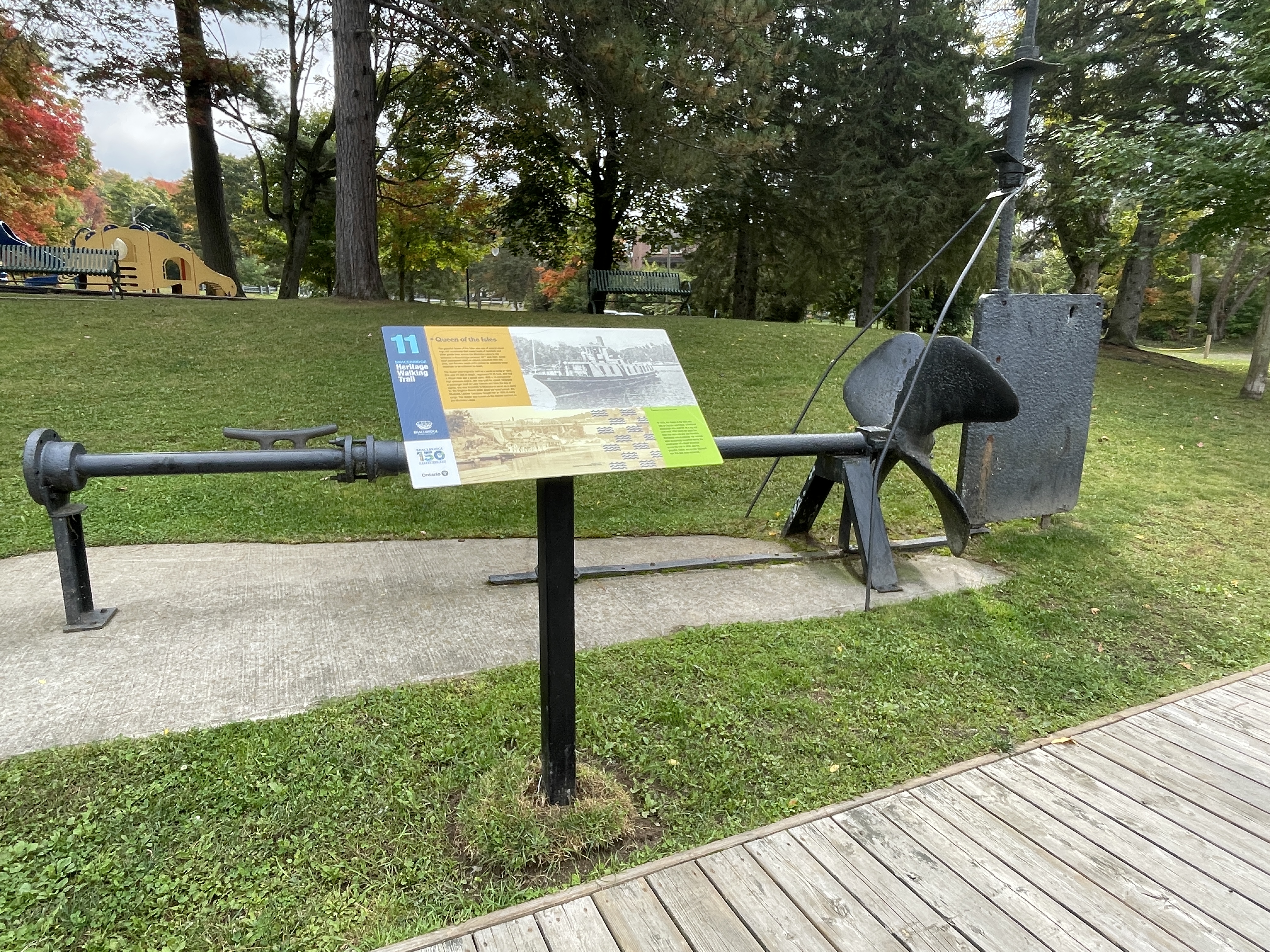
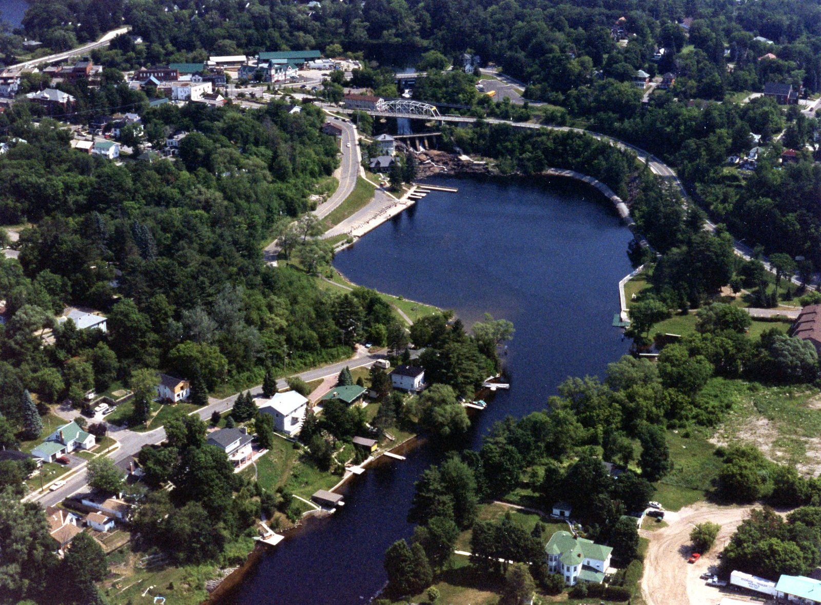
Skip to main content Skip to footer

Heritage Walking Trail

Heritage Walking Trail

The Bracebridge Heritage Walking Trail, originally conceptualized as part of Bracebridges 100th anniversary and installed in 1981, takes visitors along a path of local monuments, historic sites and destinations significant to Bracebridge. The trail includes 12 signs located throughout the downtown and waterfront areas on either side of the Muskoka River, and at the historic octagonal home known as Woodchester. Each sign contains photographs and descriptions of locations significant to the Town's history. While walking the trail, visitors can appreciate and utilize the park lands and trails, visit downtown shopping and restaurants, and take in the view at the Woodchester observation deck.

The Old Wharf

Built in the 1870s, the old wharf was the third wharf constructed on Bracebridge Bay. Two earlier wharfs were located on opposite banks at the foot of the falls until a growing sand bar in the centre of the bay blocked access to them. Thus, the third wharf was built. 

When the sand bar was dredged in 1908, boats could once again unload cargo at the site of the original docks, and the old wharf was no longer required. Before the railroad came, the wharf was at the core of transportation in Bracebridge. 

Minett-Shields Boatworks

Bert Minett moved to Bracebridge in 1910 and established H.C. Minett Motor Boat Works, building mahogany pleasure craft on the Muskoka River. 

Bryson D. Shields joined the business in 1926, and while Minett constructed the boats, Shields looked after the business side. 

Most of the boats were purchased and used by summer tourists. Aside from pleasure craft, Minett also built a 50-foot-long harbour craft for use during World War II. These boats were often seen making trial runs down the Muskoka River. 

The business closed around 1948 because of the competition from fiberglass boat makers. 

John Dunn Boatworks

In the 1890s, John Dunn came to Bracebridge and worked at Singleton Brown's shingle mill while saving money to start his own business renting boats.

By the early 1920s, Dunn was able to open his own boatworks where canoes and rowboats were built for summer visitors and residents alike. The boatworks closed in the late 1940s due to competition from new materials and boat builders. 

In addition to his boatworks, John Dunn operated a water taxi service for travellers, and ran the skating rink on the Muskoka River for many years. 

Bracebridge Falls Generating Station

Prior to 1900, electrical power in Bracebridge was provided by the Bird's Mill Pumping Station. Demand for electricity grew rapidly as electric lights were installed throughout the town, creating the need for a larger generator. 

in 1901, a hydro-electric powerhouse was equipped with a 300-kilowatt generator was constructed at the foot of the falls, costing roughly $12,000. Bracebridge Town Council encouraged the town to shift from steam power to electricity, and the demand grew once again by the end of 1904. A second generator was added , identical to the first in 1905, which acted as the town's main power source for many years. 

The original water passage and pumping mechanisms were replaced in 2010, with the new technology being carefully installed under the existing building to continue to provide electricity using Bracebridge Falls. 

Bracebridge Bay Park

In 1969, Bracebridge Town Council began a restoration program for a section of shore along the Muskoka River. The goal was to bring attention to the historical importance of the waterway and enable residents and visitors to view it as pioneer explorers and settlers once did. 

With financial assistance from the Governments of Canada and Ontario, the first phase of the Bracebridge Bay Park was completed and officially opened by the Lieutenant Governor of Ontario, the Honourable John B. Aird, on July 17, 1981. 

This park is a lasting memorial to early pioneers who persevered to create their own community in spite of great hardships, and by doing so, developed Bracebridge as a focal point for the District of Muskoka. 

Manitoba Street

Manitoba Street was originally known as Muskoka Road, as it acted as a continuation of Muskoka Road coming from Severn Bridge. In 1867, it was renamed Manitoba Street to honour Canada's confederation along with the naming of Quebec Street, Ontario Street, and Dominion Street. 

The location of Manitoba Street is believed to be a reflection of Bracebridge's first settler homestead, built by John Beal. The street would have run past his home and acted as a map marker for travelers. 

In 1876, the first wooden sidewalks were installed, and in 1879, the road was upgraded from dirt to stone. Manitoba Street has always been the heart and activity hub of downtown Bracebridge and has constantly been improved upon to better serve the community. 

Bird Woollen Mill Warehouse

Henry Bird founded the Bird Woollen Mill in 1872 and by 1888 had grown the business enough to begin expanding. Over the next 25 years, various buildings and warehouses were added to the Bird Woollen Mill complex to support its continued growth. The mill thrived for many years but eventually closed in 1954. 

The Bird Woollen Mill complex fell into disrepair over the next 10 years. A single warehouse, originally built in 1918, was sold to H.J. Brooks and Sons for $3,000 in 1966, one year before the demolition of the remaining buildings. The warehouse was purchased by the Town of Bracebridge in 1990 and used briefly for storage. 

In 1991, a proposal was introduced to repurpose the old warehouse. Renovations began in 1993 and the building became home to the Bracebridge Chamber of Commerce and the Visitor Information Centre for decades to follow. This building, commonly known as Bird Mill Mews, is the only structure from the Bird Woollen Mill complex still standing. 

Bird Woollen Mill 

In 1872, Henry Bird built a two-storey wooden building, measuring 30 by 50 feet, to house his woollen mill. The building had second-floor living quarters where Henry and his family lived until 1882, when their home, Woodchester, was finished. 

The mill was built close to Bracebridge Falls to take advantage of the water pressure, which powered the mill using the Bird's Mill Pumping Station. 

Local wool was washed, dried, graded, dyed, carded, and spun, producing high quality coats, blankets, and yarn. During World War I, 90 percent of the mill's output was directed towards the war effort, providing material for Canadian military blankets and uniforms. 

As the logging era ended and synthetic materials became more common, demand for wool declined, causing the Bird Woollen Mill to close in 1954. In 1967, a controlled fire was set by the Bracebridge Fire Department in the abandoned mill to make way for a parking lot. 

Bird's Mill Pumping Station

In 1892, W.S. Shaw built an eighty-horsepower generating station to supply hydro-electric power to the Shaw Cassels Tannery. Two years later, the Town of Bracebridge purchased this station for $3,500, becoming the first municipality in Canada to own and operate a public utility of this kind. 

The water used to power the hydroelectricity came from a dam built by the Bird Woollen Mill, who lent its name to the pumping station. 

To meet the town's growing demand for electricity, two electric water pumps were added to the plant in 1869 and 1900. In 1905, after a larger generation plant was built at the foot of Bracebridge falls, this generator was no longer needed and was used solely for water pumping. 

The Old Town

When the first residents settled in Bracebridge with intention of farming the land, they were met by untamed wilderness. They cut down trees and cleared the land to build homes and farmland, all of which needed to be done by hand. This was a grueling task, but necessary to the development of the budding community. Early pioneers built and lived in log and wood cabins until there was enough industry to improve the structures. 

Bracebridge received its name from Washington Irving's novel "Bracebridge Hall" and was adopted in 1864, chosen by William Dawson LaSueur, who was the postmaster at the time. 

Bracebridge was officially incorporated as a town on January 1st, 1875. With continued expansion to the boating and railroad industries, the permanent population was growing, establishing Bracebridge as the heart of Muskoka. 

Woodchester

After establishing his woollen mill in 1872, Henry Bird began constructing a home for himself and his family that overlooked the mill and the Muskoka River beyond. The home took 10 years to build, and in 1882 the family moved in. The home was named "Woodchester" after a hamlet near Bird's boyhood home in Gloucestershire, England. 

Henry Bird and his wife, Mary Ney, had seven children together. Their three daughters - Catherine, Margaret, and Mary - lived in the home until the late 1970s. Woodchester was then purchased and restored by the Rotary Club of Bracebridge with assistance from the Ontario Heritage Foundation and private donors. There is an Ontario Heritage Easement placed on the building, protecting the home and its historic features. 

Woodchester is one of the finest 19th century octagonal buildings remaining in Ontario, and an early example of poured concrete construction. It contained many innovations, including indoor plumbing, electricity, a dumbwaiter, speaking tubes, and ventilation shaft. 

Railway and Bridge

The Northern Railway came to Bracebridge in 1885. Before this, transportation to Bracebridge was by horse, on foot, or by steamer from Gravenhurst, The railroad vastly improved transportation facilities for the lumber industry and was a boost to the local economy, allowing goods and services to be more easily moved between settlements.

To build the railroad through Bracebridge, a bridge was constructed over the Muskoka River and rocks were hand cut south of the river to make a continuous path. Regular service for passengers began June of 1886. The original Bracebridge station was located near the river, and a round wooden tank was used to fill steam engines with water supplied by a turbine at the river. 

The railroad was essential to the town's growth during its formative years and was the primary mode of transport for people and goods to and from the community. 

Corduroy Road

Before the railroad reached Bracebridge, travel was primarily done by horse and wagon along local roads. In swampy or rough areas, corduroy roads were often used. These primitive roads were built by laying logs side by side across the path, creating a more stable surface where the ground was too soft or muddy for regular travel.  

The corduroy road running along the Muskoka River was called Mill Road. It provided access to the grist mill and to the original steamboat landing on the south side of Bracebridge Bay. 

Log Chute and Boom

The lumbering of white pine in Muskoka began in the 1850s and the lumber industry boomed, which motivated settlers to come to Bracebridge. 

In 1872, a log chute was constructed to allow logs to bypass Bracebridge Falls. It started at the northern bridge, now Entrance Drive, and ended at the bottom of the falls. The log slide was a flat-bottomed trough, supported by trestles. Logs were funneled into the slide by a V-shaped log boom above the chute. 

Workers stood at the mouth of the slide to prevent the logs from jamming. Another boom stretched across the mouth of the bay to stop the logs from floating downstream. Often the Muskoka River was so full of logs that boats couldn't use it as a transportation route. 

Bracebridge's logging industry reaches its peak in the 1880s by the 1900, the log chute was torn down to make way for a new generating station. It was never rebuilt, as the logging industry was in decline. 

Grist Mill

Alexander Bailey settled in Bracebridge in 1863, and a year later, he constructed a 30-by-50-foot grist mill. The building was three stories plus an attic, with the second floor being the main milling area. It was powered by a water wheel, used to grind wheat into flour. 

One of the earliest desires of pioneers was to have a grist mill, as home grinding of wheat was difficult and produced course brown flour. The Bracebridge grist mill could produce 75 barrels per dat for the original settlers. In addition to grinding flour, the mill could chop grain for horses. 

After many years of service and various operators, the grist mill burned down June 20, 1909. It was never rebuilt due to competition from more efficient steam-run mills being operated in larger cities. 

Singleton Brown Shingle Mill

In 1885, J.D. Shier and Singleton Brown started a shingle and lumber mill located where the North and South branches of the Muskoka River meet. This partnership ended a few years later, and Mr. Brown built a new shingle mill. He continued to manufacture shingles until 1899 when the price of shingles fell, and the mill closed as it was no longer profitable. The buildings stood until they were damaged by sever spring floods and had to be demolished. 

Indigenous History in Muskoka

Since time immemorial, the geographic region now known as Muskoka was the traditional hunting grounds and homelands of many nations, including the Anishinaabeg, Haudenosaunee, Huron-Wendat. The Anishinaabeg include the Ojibwe, Odawa, and, Potawatomi, who are collectively known as the Three Fires Confederacy. These Nations used the land for hunting, fishing, trapping, and trade, and were united together in peace and harmony under The One Dish, One Spoon Treaty, 

It is generally believed that the name "Muskoka" is derived from William Yellowhead, is also known as Chief Musquakie, a prominent Ojibwe chief who led his people in the area that now encompasses the Muskoka Region. Recognized as Chief Musquakie's hunting grounds, the Muskoka River was one of the main canoe routes from Georgian Bay to the Ottawa River and the St. Lawrence River. Before the arrival of Métis and European settlers, this area of the Muskoka River was a landing site and a gathering place. 

In 1830, the government forced Anishinaabeg communities to surrender their land and relocate to a government-designed area near Coldwater, Ontario. This process was known as the Coldwater Experiment and is one of the oldest examples of the reserve system in Canada. 

Two treaties apply to the Muskoka Region: the Robinson-Huron Treaty of 1850 and the Williams Treaty of 1923. In 2015, the Truth and Reconciliation Commission of Canada published 94 calls to action, which aimed to advance reconciliation between Indigenous and non-Indigenous peoples. 

In 2024, the See Muskoka Through Our Eyes, first traditional Powwow took place at Annie Williams Memorial Park. This event encouraged Indigenous and non-Indigenous communities to learn about and from one another to foster positive relationships. Indigenous food and craft vendors, music, dance, and educational presentations were enjoyed by all attendees. To mark the occasion, a commemorative red oak tree was planted in the park on September 27, 2024, symbolizing the moment communities came together to begin the shared journey of healing and reconciliation. 

Queen of the Isles

The graceful Queen of the Isles was one of several steam tugs and scowboats that towed loads of tanbark and other goods from across the Muskoka Lakes to the tanneries in Bracebridge between 1877 and 1925. Many local businesses relied on natural resources from the area, and farmers made extra money by preparing these materials to be collected by boats. 

The Queen was originally built as a Yacht in Orillia in 1885. She was 72 feet in length, registered 27.35 tons, and had a clipper bow and fantail stern. With a 15-horseppower high pressure engine, she was built for speed. Originally a passenger boat on Lake Simcoe and later the Bay of Quinte, she was imported to Muskoka to serve as a yacht for the Brighton Beach Club. After the hotel burned, the Muskoka Leather Company bought her in 1895 to carry cargo. The Queen was known as the fastest towboat on the Muskoka Lakes. 

In 1925, the Queen of the Isles was sold to Captain Levi Fraser, a freelance boatbuilder who user her as a tug and work boat. After nearly ten years the boat was worn out and was therefore dismantled and abandoned. Her remains were accidentally unearthed during the construction of the sewer forcemain across the river in 1993, and the propeller, rudder, and anchor displayed near this sign were recovered. 

Muskoka Falls

In its early history, this thundering waterfall was known as Grand, Great, South, or Muskoka Falls. There falls measure 33.2 meters (109 feet) high and have been noted in the writings of early explorers and surveyors - Henry Briscoe (1826), Alexander Shireff (1829), F.H. Baddeley and John Carthew (1835), David Thompson (1837), and Robert Bell (1848). 

Muskoka Falls became a community in 1862 when a post office was established, with Richard Hannah serving as its first post master. Settlers in Bracebridge, then called North Falls, came here for their mail until the Bracebridge post office was established in 1864, the same year the town was renamed Bracebridge. 

In 1907, Gravenhurst established a power plant at Muskoka Falls. Ontario Power Generation took over operation of the plant in 1915. It was expanded and reopened in 1916, increasing power supply to Bracebridge and the surrounding communities. 

A new, more efficient hydro turbine was installed at the plant in 2019. The South Falls Generating Station is still operated by Ontario Power Generation and has been providing the community with hydro-electric power for over a century. 

This website uses cookies to enhance usability and provide you with a more personal experience. By using this website, you agree to our use of cookies as explained in our Privacy Policy.